


Coffee Pot Rock Trail In Sedona
Reviewed and updated by AZ Leisure Staff Writers on .
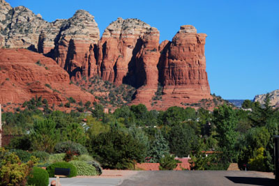 Coffee Pot Rock, Sedona Arizona
Coffee Pot Rock is one of West Sedona's most recognizable red rock formations, named for its resemblance to an old-fashioned percolator with a distinctive spout. Rising above the neighborhoods of West Sedona, the formation can be viewed from numerous locations around town and explored more closely from the network of hiking trails near Teacup Trail and Sugarloaf.
- Coffee Pot Rock Overview
- Hiking Coffee Pot Rock
- Trail Details
- Scenery & Views
- Coffee Pot Rock & Vortexes
- Trailhead & Directions
- Hiking Tips
- FAQ
Coffee Pot Rock In Sedona
Coffee Pot Rock rises above West Sedona near a network of trails that includes Teacup Trail, Sugarloaf Loop and Thunder Mountain Trail. Its unusual profile is easiest to recognize from the south and southeast, where the projecting rock resembles the spout of an old-fashioned coffee percolator.
The formation is visible from many parts of West Sedona, but hiking into the surrounding trail system provides closer views along with broad panoramas of the city's red rock landscape.
Hiking Near Coffee Pot Rock
One of the primary hiking routes near Coffee Pot Rock is Teacup Trail, which crosses the red rock terrain beneath the formation and connects with other West Sedona trails. The Coconino National Forest currently lists Teacup Trail at approximately 2.0 miles with about 200 feet of elevation change.
Teacup Trail connects with the Sugarloaf and Thunder Mountain trail network, allowing hikers to create routes of different lengths. Because several trails intersect in this area, total hiking distance depends on the trailhead and combination of trails you choose.
The terrain includes packed dirt, exposed rock and uneven sections typical of Sedona's red rock trails. Stay on established routes rather than following unsigned social trails, both for easier navigation and to help protect fragile desert soils and vegetation.
Coffee Pot Rock Trail Details
- Primary nearby trail: Teacup Trail
- Teacup Trail length: Approximately 2.0 miles
- Elevation change: Approximately 200 feet
- Connected trails: Sugarloaf Loop and Thunder Mountain Trail
- Terrain: Dirt trail, exposed sandstone and uneven rock
- Shade: Limited
- Water: Carry your own drinking water
- Best use: Hiking and scenic red rock views
- Season: Year-round when weather and trail conditions permit
Views From The Coffee Pot Rock Area
The trails around Coffee Pot Rock provide close views of the formation as well as broad panoramas across West Sedona. Nearby Chimney Rock, Thunder Mountain and other red rock formations become visible from different points along the trail network.
The open terrain also provides excellent opportunities for photography, particularly during early morning and late afternoon when lower-angle sunlight emphasizes the colors and layers of the surrounding sandstone.
Is Coffee Pot Rock A Sedona Vortex?
Coffee Pot Rock is sometimes associated with Sedona's broader spiritual and vortex traditions, but it is not one of the four best-known vortex locations identified by Sedona visitor information. Those commonly recognized sites are Airport Mesa, Cathedral Rock, Bell Rock and Boynton Canyon.
Visitors interested in Sedona's spiritual traditions can still enjoy the quiet red rock setting around Coffee Pot Rock for hiking, meditation and scenic views without treating the formation as an officially designated vortex site.
Coffee Pot Rock Trailhead And Directions
Coffee Pot Rock is located above West Sedona north of State Route 89A. A common hiking access point is the Sugarloaf Trailhead, which connects with the Sugarloaf and Teacup trail system near the formation.
From State Route 89A in West Sedona, turn north onto Coffee Pot Drive and continue toward Sanborn Drive and the Sugarloaf Trailhead area. Follow current street and trailhead signs because neighborhood access, parking regulations and trail conditions can change.
Trailhead parking is limited, so avoid blocking driveways, private property or residential streets where parking is prohibited.
Coffee Pot Rock Hiking Tips
- Carry plenty of water because the trails are exposed and shade is limited.
- Use sunscreen, a hat and other sun protection throughout the year.
- Start early during warm weather to avoid the hottest part of the day.
- Wear sturdy footwear suitable for dirt, sandstone and uneven rock.
- Stay on established trails rather than following unsigned social paths.
- Respect nearby residential neighborhoods and all posted parking restrictions.
- Watch for intersecting trails and carry a current trail map.
- Avoid exposed trails during thunderstorms and periods of heavy rain.
- Carry out all trash and leave rocks, plants and archaeological features undisturbed.
Current Coffee Pot Rock Trail Information
Trail conditions, closures, fire restrictions and recreation requirements can change. Check current Coconino National Forest information before hiking in Sedona's Red Rock Country.
Coconino National Forest Recreation Information
Nearby Sedona Red Rock Hikes
- Airport Mesa
- Bell Rock
- Cathedral Rock
- Courthouse Butte
- Sedona Hiking Trails
- Sedona Hiking Trails Map
Coffee Pot Rock Sedona FAQ
Where is Coffee Pot Rock in Sedona?
Coffee Pot Rock rises above West Sedona north of State Route 89A near the Teacup, Sugarloaf and Thunder Mountain trail network.
Why is it called Coffee Pot Rock?
The formation is named for its resemblance to an old-fashioned coffee percolator, including a distinctive rock projection that looks like a spout.
Can you hike to Coffee Pot Rock?
Yes. Hikers can explore the area around Coffee Pot Rock using established trails including Teacup Trail and connecting trails near Sugarloaf.
How long is Teacup Trail?
The Coconino National Forest lists Teacup Trail at approximately 2.0 miles with about 200 feet of elevation change.
Where do you park to hike near Coffee Pot Rock?
A common access point is the Sugarloaf Trailhead in West Sedona, which connects with trails leading toward Coffee Pot Rock. Parking is limited, so visitors should follow all posted neighborhood and trailhead restrictions.
Is Coffee Pot Rock a Sedona vortex?
Coffee Pot Rock is sometimes associated with Sedona's spiritual traditions, but it is not one of the four best-known vortex locations identified by Sedona visitor information. Those are Airport Mesa, Cathedral Rock, Bell Rock and Boynton Canyon.
Can you see Coffee Pot Rock without hiking?
Yes. The formation is visible from numerous locations in West Sedona, although hiking the nearby trail network provides much closer views.
Is there shade on the Coffee Pot Rock trails?
Shade is limited on much of the surrounding red rock terrain, so hikers should carry water and use appropriate sun protection.
What other trails are near Coffee Pot Rock?
Nearby routes include Teacup Trail, Sugarloaf Loop and Thunder Mountain Trail, allowing hikers to combine trails for outings of different lengths.
See All Sedona Has To Offer
Sedona Annual Events
Grasshopper Point
Sedona In Autumn
Directions To Sedona
Directions From Phoenix
Red Rock Sycamore Loop
Sedona Tours
Sedona Air Tours
Chapel Of The Holy Cross
Miles From Sedona
Arizona State Map
Shuttles & Transportation
Sedona Pictures
More Sedona Pictures
Sedona Video
About Sedona











